T.L. Morrisey

Wednesday, December 15, 2021

Burying the St. Pierre River Has Begun


Yesterday morning I walked to Meadowbrook Golf Course; it was a beautiful sunny day, not a single cloud in the sky. Court ordered work to bury the last section of the St. Pierre River has begun. On the far right of the above satellite image you can the St. Pierre River, it's just below Toe Blake Park; the river runs in a fairly straight line until it meanders and then, finally, empties into a culvert at the train tracks. I learned a few things in high school Geography and one of them is that a meandering river is very old, that it was once a more powerful river but is not as powerful as it once was, when meeting obstacles it meanders around them rather than over them. However, this river may have never been anything but a creek; it begins as a stream on Mount Royal and then runs across the city to empty out at the St. Lawrence River. Of course, even Mount Royal was once a much larger mountain but has been worn down by erosion and time.

It must seem a big issue is being made of something fairly insignificant. What the river represents is the last vestige of a historical river, it represents the presence of nature in the built city environment that can be relentlessly soulless. All people need the presence of nature as a place to enjoy the outdoors and we know that the outdoors--a forest, a river, a field--gives meaning to life, it restores one spiritually, it recharges one's batteries. This is what the river and the golf course represent, even though most people will never walk here or see the river. That it exists and its possible future use as a nature reserve, a park, or still a golf course is what is important. It is important not to lose this land to more condo construction.

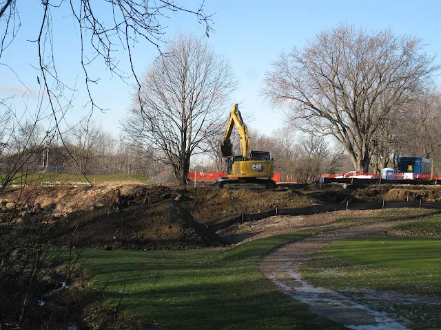
Here are some photographs of the burying of the river. I see that the plan is to dig a straight trench between where the river enters the golf course below Toe Blake Park and where it leaves at the culvert. This water will be diverted into culvert pipes.


This part of the river, that meanders, is cut off 


Tuesday, December 14, 2021

Community Garden at St. Thomas Anglican Church

Located at Rosedale Avenue and Somerled Avenue, St. Thomas Anglican Church has a long history in Montreal; the community garden is behind the church. I took these photographs on the last day of November, it was about -3 C and cold, some snow had fallen a few days before and was still on the ground. You can't see what they grow here but it seems to be more vegetables than flowers. The caretaker came out as I was standing looking at the garden, I mentioned that for some reason Covid had been good for gardens, they've flourished last year and this, but he said it was sad that so many people had died. Let's hope this snow melts before our long winter sets in. 


Sunday, December 12, 2021

Egoût collecteur Rivière Saint-Pierre,1933

Here are historical photographs taken on 31 October 1933 showing the burying of the St. Pierre River. The only section of the St. Pierre River still above ground is in Meadowbrook Golf Course and it is slated to be buried. The question is, why? Because it is polluted with fecal matter from incorrectly connected sewer pipes near the golf course? Isn't the common sense thing to do is to stop the pollution, not bury the river? I suppose the cheaper thing to do is to bury the remaining exposed section of the river. But government has a lot of our money they can spend any way they want and common sense isn't something government is known to have. 


This is a section of the St. Pierre River before it was covered but not necessarily the same section as in
the photographs below ...


Tuesday, December 7, 2021

Old Photos of the St. Pierre River

 These photographs are saved from a Facebook page, Historical Montreal Photographs. 


Photograph of the St. Pierre River, from the McCord Museum looking south towards a bridge at Western Avenue, at The Glen in Westmount, in 1889.


This, and the following photo, are from 1 June 1938, of a concrete bridge over the St. Pierre
River. I think this might be at Westminster Avenue near the future Westover Avenue. 


See above.


Aerial photograph from the late 1940s, showing the course of the St. Pierre River, 
notably Cote St. Luc Road and Westminster. It's mostly farmland and (I think) it shows
the St. Pierre River intersecting present-day Westminster Avenue and the future Westover Avenue.
You can also see the farm buildings in the photo of the cement culvert above, 
which suggests that the two other photographs were taken looking west. 


A 1903 map showing where the St. Pierre River emptied into the St. Lawrence River. 


Sunday, December 5, 2021

Historical Maps of the St. Pierre River

Historical maps to locate the St. Pierre River. 


This map, showing the St. Pierre River (in 1696?), is found in a history of Loyola College; you can see
the river on the top right and how it forms the Petit Lac St. Pierre in the bottom foreground. 


Map from 1739; you can see the St. Pierre River beginning on Mount Royal, 
going through present-day Cote St. Luc and Montreal West, then forming a lake
in what were the Turcot train yards before emptying out at the St. Laurent River.


Another old map, from 1744, showing the Island of Montreal, surrounding areas, and St. Pierre River.


Here is a contemporary map showing the St. Pierre River highlighted in purple.


Friday, December 3, 2021

St. Pierre River on a Cold Day

Photos taken on 28 November 2021 after the first snowfall. 

It was a cold day but there were dog walkers and their dogs, and always a friendly "Good Morning". Why is this creek so important to people? Why not build more condos? Someone told me that the golf course is protected from future development. I hope they are correct. But why are people so adamant that the golf course should be protected and, by extension, that the river-creek not buried? All I can say is that, personally, I think we've had enough progress and development at the expense of our environment. We need to preserve some nature (not just parks) in the city for future generations, including land and a place for urban wildlife. This isn't a park, it's a golf course, and one day I hope it is allowed to revert to its natural state, let the grass grow and wild flowers thrive. Call it Parc St. Pierre and keep it undeveloped; it could be similar to Parc Angrignon. 

What is covered can be uncovered and, I suspect, some future generation will see the St. Pierre River restored, above ground, in at least a few places. That is my hope. 

BTW, in this area, there have already been several new condo developments, several new residences for the elderly, and both Vincelli's Garden Centre and the Village Plaza on Robert Burns are slated for being demolished and apartments or condos built on these sites. Enough is enough. 


Train tracks on the left that you pass to enter the golf course.


Wednesday, December 1, 2021

Walking to the St. Pierre River

You can see something of the St. Pierre River by going to Toe Blake Park in Montreal West, the river is on the other side of the fence. Or, you can visit the river by walking down the slope at the Westminster Bridge (it is an overpass at the train tracks on Westminster Avenue) and there is an open gate, walk along the path until you come to a parking lot behind some apartments, then proceed to the golf course from there. Suggestion: go soon.

Here is the path to the river from the railway overpass bridge on Westminster Avenue.